The Roman Fort at Reculver 1965
Work during March, April and June was concentrated on the exposed cliff- section of the fort overlooking the beach. This section continues to be threatened by storms and tides. The eroded cliff-face was cut back to a vertical section and the levels examined. Ditches and pits of Iron Age date were located cut down into the natural and contained pottery and flints; sealing these was the fort construction- layer dating to c. A.D. 210. A wide gravel road was found, running east-west, and dividing
the praetentura into two unequal parts. North of this, the corner of a substantial building was examined, perhaps a barrack-block. South of the road, an interesting building with traces of opus signinum flooring was found. This may relate to the hypocausted structure found nearby in August, 1964.
B. J. Philp
The Roman Fort at Reculver - Reculver Excavation Group May 1966
During August the Reculver Excavation Group completed its largest single excavation inside the Roman fort since work began in 1952. Some 70 members of the Group took part in the excavations and several thousand visitors were given progress reports by appointed guides. Members of the Kent Archaeological Society were given a special guided tour of the entire fort and a detailed account of the current excavations. More than 1,000 of the Group's booklets on the fort were sold and a fourth edition may soon have to be printed.
The excavations were carried out immediately east of St. Mary's Church, where a substantial masonry building was found in 1964. This was totally excavated and proved to be a bath building. Its west end partly ran under the later churchyard which restricted excavations. However, the building was found to be more than 40 feet in length. It was divided into three equal divisions each containing hypocausts and an apsidal chamber. The hypocaust in one of these chambers had subsequently been destroyed and a cold- plunge-bath inserted. This bath, itself subsequently reduced in size, survived intact. Masses of painted plaster and smashed box-flue tiles were found in the ruins of the bathhouse and now await detailed study. Some of the walls had clearly been replastered at least once, perhaps when the cold-plunge bath had been added. Some of the painted designs showed double medallions in red enclosing uncertain central figures. Pottery and coins were also recovered. The furnace, also heavily robbed, was at the east end.
Immediately south of the bath-house was found a large stone-lined drain running alongside the Via Principalis and probably draining out through the east gate of the fort. The drain was completely filled by fine silt and closed with large sandstone boulders. The main-road (Via Principalis) was itself found intact for the first time and this makes a particularly useful addition to the fort-plan. The road had been remetalled at least once. 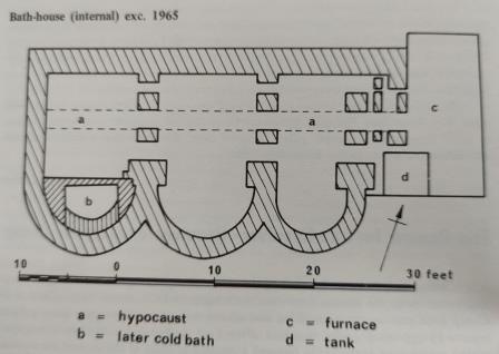
Another large masonry structure was found close to the first, but at right-angles to it. This also contained a heavily robbed hypocaust and a very large apsidal chamber. It also seems to have been a bath-building. The northern end of this building was found to have been destroyed by sea erosion when the cliff was cut back some years ago. Its overall dimensions can, however, be determined.
Metalled roads and paths were also located on four sides of an unexplored area close to the east gate of the fort. Partly covered by existing buildings this area may contain another important structure.
Excavation of the East Gate of the Roman Fort at Reculver Nov 1967
The large-scale summer excavation at Reculver was completed in September. Two sites, the east gate of the fort and an area south of the Via Quintana, were examined. The east gate site proved to be of unusual interest and importance. It was found to consist of a single carriage-way, some 8ft. 6in. wide, flanked by massive masonry piers 16ft. long and 5ft. wide. The latter must have supported a small tower, or gatehouse, which probably rose to a height of at least 25ft.
On the north side was a guard-room, some 8ft. x 6ft. internally, in an exceptionally good state of preservation. It was partly contained within the thickness of the fort wall, but also projected internally for several feet. It seems that the guard- room had not formed part of the gatehouse, but probably had contained a wooden stair giving access to both the tower and the rampart-walk. It was not possible to determine the exact arrangements on the south side of the gate owing to the presence of a surfaced footpath. It seems, however, that there was no guard-room on that side.
The recovery of a large part of the east gate plan enables that of the south gate to be completed. The south gate, excavated by the Group in 1964, was found to have been heavily robbed. What had survived indicates that the south and east gate must have been built on very similar lines and also suggests that all four gates of the fort had a common plan. The carriage-way of the south gate was also 8ft. 6in. wide and the piers similar to those recently found.
Only one continuous layer of road metalling was found at the east gate and this was composed of shingle and pebbles, from the foreshore, as noted elsewhere on the site. Set across the line of this road towards the front of the gatehouse, was a series of sandstone blocks. These formed a low rim against which heavy wooden doors must have closed. Similar rims occur in the gates of the fort at Gellygaer and elsewhere. Indeed the south gate excavation revealed sockets which indicated that the doors there must have been in a forward position though this could not be proved on the east gate site.
The large chamfered sandstone block which has stood in an upright position alongside the path at the east gate for more than 40 years (V.C.H. III (Kent) Vol. III. p. 19 and Arch. Cant. LXXIII (1959), p. 103), was replaced in its original position on the west side of the north pier. It had been extracted in mid-Victorian times when an attempt was made to cut a well to serve the old Coastguard cottages nearby. The diggers had succeeded in shifting the chamfered block, but gave up when they encountered the really massive jamb-base beneath. As though in spite they then dug their well right through the centre of the guard-room! Workmen laying a 5-inch water-main sometime in the 1930's had been rather more persistent. They dug their trench through 16ft. of solid Roman masonry cutting up through the south pier of the gate. Had they trenched some 9 inches to the north they would have missed the masonry and dug along the line of the pebble road.
One of the most interesting aspects of the east gate was that it was found to have been blocked in Roman times. A substantial wall had been built across the road against the original rim with its external face flush with the outer face of the fort wall. This blocking probably dates from the late-third or fourth centuries. The blocking, or partial blocking, of the gates of early forts still in use in the late-third or fourth centuries occurs commonly in the North. In this Reculver can be seen to follow the same trend, for as an early-third century fort it too was provided with four gates (the north and west gates were washed into the sea before 1800). By the late-third century when it was "reconditioned" (probably during the anti-Carausian invasion scare) it was made to conform with newly constructed forts, as at Rich- borough and Burgh Castle, which were provided with only one main gate and small posterns. In plan, too, the gates at Reculver can be seen to be part of the typological link between those of the second and fourth centuries.
The rampart-bank, formed largely of soil dug from the fort's defensive ditches. was found to enclose the guard-room on the north and west sides. A large section of this bank was removed and found to seal a worn sestertius of second-century date, two bronze brooches and a small amount of pottery of late-second or early-third century date. This evidence provides additional confirmation of the date of the fort's construction very early in the third century A.D.
A silt and rubbish layer was found to cover the surface of the rampart-bank. This contained masses of finely painted wall-plaster and the iron-studded sole of a leather boot which was raised intact. A large pit had been dug into the rampart just outside the guard-room and this contained animal bones, pottery and three coins. One was of Severus Alexander (A.D. 222-235) and another was of Allectus (A.D. 293-296). Several feet east of this pit and cutting through part of the guard-room wall was an abortive well-shaft containing pottery of medieval date.
The excavations this summer represent the largest project so far attempted at Reculver. More than 80 members of the Group assisted with the work and various research groups, local societies and some 7,000 members of the public visited the site. More than 900 of the Reculver booklets were sold and the extra copies of the August "Kent Archaeological Review" sold out completely. It was also possible to rebox the entire Reculver collection in the research-centre and to weather-proof and re-organise the drawing-office. A complete series of datum-pegs was concreted into position across the entire fort as the Ministry has recently cleared all the bushes and bungalow foundations from the area. The service in the ruined church and the evening lectures again proved popular and will be repeated again next year.
Brian Philp.
Excavations 1968 Interim Report Reculver xcavation Group
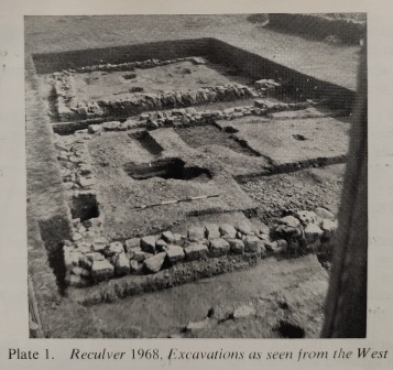
The excavations at Reculver during 1968 were completed as scheduled in October (see K.A.R. No. 14 page 12). Altogether the work, now entering its eighteenth consecutive year, has produced a vast amount of information about this major site. Its military importance in Roman times can be seen by the strategic position on the north Kent coast, guarding as it does the inland waterways to Canterbury and the Thames Estuary leading to London.
The first Roman occupation of the site was about the time of the Claudian Conquest in A.D. 43 when a small fortlet was constructed. The east and south sides of this were located in 1961-63 well within the boundaries of the later stone "Shore Fort." The "Shore Fort" at Richborough similarly covers defensive earth- works of the Claudian period. Little is known of the internal arrangements of the fortlet at Reculver owing to extensive erosion.
The same site was again selected by military engineers about 150 years later when the great eight acre stone-fort was built. Coin and pottery evidence found in 1957 indicated that this fort was built early in the third century and in 1960 the discovery of the Reculver inscription suggested a date of c. A.D. 210. It must be significant that London and other Romano-British towns were receiving their defensive walls at about this time.
The evidence from the site also suggests that there was an increased period of activity at the end of the third century. This probably related to the measures being taken against Saxon raids which at Reculver may have followed a period of inactivity or even abandonment.
The site appears to have been occupied extensively during the first half of the fourth century though again there may have been a lapse without military occupation. The coin evidence suggests that all military activity stopped at Reculver at about A.D. 360 though this pattern is not reflected at several other "Shore Forts." The garrison of the fort is known, both from a written account (Notitia Dignitatum) and stamped titles, to have been the First Cohort of Baetasii.
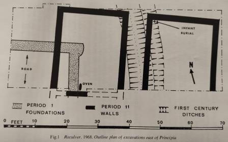
The excavation undertaken in August and September 1968 aimed at throwing more light on the various phases of military occupation. An area east of the Principia and immediately south of the Via Principalis was selected and a large excavation undertaken (Fig. 1) It was known from earlier work that all the phases described might be represented at this particular point.
The east side of the first century fortlet was picked up under later masonry buildings on a known alignment. It took the form of two parallel ditches the inner one 12ft. wide and 7ft. deep and the smaller outer ditch 5ft. wide and 3ft. deep.. The inner ditch was Y-shaped in section and the outer V-shaped. The larger ditch appears to have been partially filled and then left to silt. The primary filling contained several potsherds of Iron Age date and the mud-silt above pottery of Belgic type dating to the middle of the first-century A.D. This ditch also appeared to be swinging to the north-west and this suggests that the north line of the fortlet lies buried beneath existing cottages, a later Roman bath-house and part of the medieval churchyard. Certainly this would explain its absence from all earlier sections in this area!
At the time of the fort's construction in c. A.D. 210 a very substantial build- ing was planned for this area on the same axis as the east wall of the fort. Its foundations, of consecutive layers of beach pebbles, were found in the south-west corner of the excavation. Further work in October revealed the corresponding south-east corner of this building and it now remains for the western side to be located. There was no evidence to suggest that this building was completed or that any more than the foundations were laid. This tends to confirm the suggestion, based on similar evidence elsewhere inside the fort, that the fort may have been temporarily abandoned shortly after its construction.
How long any such abandonment lasted is not known, but it is clear that the planned structure was completely superseded by a pair of substantial buildings the northern ends of which were uncovered during the excavations. The new buildings, aligned on a slightly different axis, extending northwards to a new frontage line and clearly overlaying the original foundations indicate a drastic change of plans and also suggest a different period of occupation.
The floors and walls of the later buildings were of clay, the latter no doubt being held within a stout wooden frame resting on very substantial masonry foundations. The walls of the eastern building, at least, had been plastered and painted and each probably had heavy, tiled roofs. It seems probable that these buildings were barracks and their position in the central division of the fort close to the Principia suggests some special importance.
The eastern building fell into disrepair and collapsed by degrees. The floor was covered by a thin band of carbon from small fires and in the corner, cutting through the carbon, was an infant burial. Several large pieces of iron, bronze coins and broken bronze objects were found scattered about. Part of the west wall had then collapsed across the debris and included fragments of roof-tile. Again a thin band of carbon collected and more metal fragments, to be sealed yet again by a final fall of wall and more tiles from the roof. This activity is more akin to squatters than to a military garrison and it may indicate that the fort was vacated for some time. Whatever the circumstances it is clear that despite subsequent use of the site by troops no attempt was ever made to rebuild this barrack in any form. Instead is slowly submerged beneath a thick layer of domestic rubbish.
More than 100 coins were found in association with these two buildings though until these have been cleaned precise dating is not possible. It seems, however, that all the coins sealed beneath the collapsed walls date to c. A.D. 270-300 and that the rubbish above includes coins of the first half of the fourth century. From this it is tempting to suggest that the conjectured withdrawal of troops, resulting in the neglect of the barracks, formed part of a re-organisation by Constantius after A.D. 296.
Of particular interest was a fragment of a brick stamped with the letters CIB, the sixth so far found on the site. This was sealed beneath the layers of fallen wall in the eastern barrack and, if the coin evidence is correct, the First Cohort of Baetasii must have been at Reculver during the third century A.D. Whether they actually built the fort and were also the garrison at the end of the third century has not yet been determined.
It is clear that no other masonry structures were ever built on this site though it is possible and likely that there were wooden buildings here during the first half of the fourth century. Several unsealed post-holes were found above the western barrack, but they did not appear to form any coherent plan. Medieval and later pits were also found.
Another interesting programme of work has been planned for 1969 and it is hoped that formal training will be continued.
BRIAN PHILP
The Reculver Inscription Aug 1969
It was on the 3rd September, 1960, that the first piece of the famous Reculver Inscription was found. Mr. A. O. Lewington, then in his second year of member- ship of the Reculver Excavation Group, made the dramatic discovery. He was diligently working in the cellared strongroom of the headquarters building (principia) with other members of the Group where more pieces were to be found in the next few days. To any volunteer this was the perfect 'find,' an hitherto unknown document relating to a remote period of our history and destined to be the most important single find from the entire 350 miles of the "Saxon Shore."
By the end of the 1960 excavation eleven fragments of this commemorative tablet, now known as the Reculver Inscription, had been recovered and these represented about three-quarters of the complete text. The inscription must have been placed on the wall of the sacellum from where it eventually fell into the strongroom below.
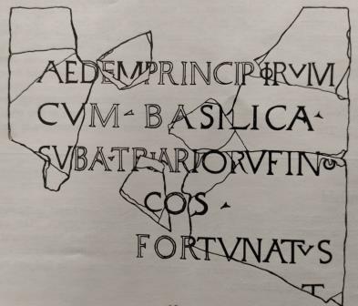
The late Prof. Sir Ian Richmond kindly agreed to study the fragments and his reconstruction and interpretation are given here (see The Antiquaries Journal, Vol. XLI (1961), page 224).
It seems that the shrine of the standards (AEDEM) of the headquarters (PRINCIPIORVM) together with (CVM) the crosshall (BASILICA) were built under (SVB) the consular governor (COS), A. TRIARIVS RVFINVS. The work was carried out by FORTVNATVS who was probably the commander of the fort. Triarius Rufinus was consul at Rome in A.D. 210 and Prof. Richmond suggested that he probably became governor of Britain in about 210-216.
This inscription may almost be regarded as the 'foundation tablet' of the fort itself as it records the building of the major building on the site, doubtless one of the very first to be built inside the defensive walls of the fort. Happily, this early date agrees very closely with coin and pottery evidence recovered from the fort in 1957 (Arch. Cant., LXXIII (1959), 96), and later. Prior to the present series of excavations, started in 1952, the fort had always been regarded as of late-third century construction in common with many of the other 'Saxon Shore' forts. In recent years, however, it has been possible to show that the fort's structural characteristics are of earlier form. Details such as the rounded corners, lack of external bastions and bonding courses, the formal layout of roads and buildings and the gateways in the centre of each side to name the more obvious.
Recently, Mr. R. P. Harper (Anatolian Studies, Journal of the British Institute of Archaeology at Ankara, Vol. XIV (1964), 163) has suggested that Q. ARADIVS RVFINVS may have been the consular governor of the Reculver Inscription. If so, he would have been in office sometime in the mid 220's.
Either way it is clear that the fort was built in the early-third century and this single fact has necessitated some considerable revision of Roman military history of the third century. Prof. Richmond also added about the inscription "epigraphically, its importance lies in the fact that this is the first time the inscribed phrase aedes principiorum can be applied to and identified with the official shrine of the headquarters buildings, hitherto unmentioned in any inscription. It is also the first certain instance of the application of the name basilica to a military crosshall, although the resemblance between these buildings and a civil basilica has often been stressed." So, too, does it add another name (RVFINVS) "to the meagre list of third century consular governors." Mr. Lewington can be well satisfied with his find!
Another interesting programme of excavations has been arranged for August 1969. This will involve more work inside the Roman fort when buildings, roads
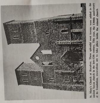
and ditches should be uncovered. For the first time, too, excavations will be carried out inside the famous Saxon church now celebrating its 1300th anniversary since its foundation in A.D. 669. Visitors will be welcomed between 5th-30th August. An exhibition of finds and drawings will be prepared and guides will show visitors and parties around the site. The site is only four miles from Herne Bay station and there is a frequent 'bus service.
Brian Philp
The Roman Fort at Reculver Summer Excavation 1969 Reculver Excavation Group
The large-scale summer excavation at Reculver was completed in September in co-operation with the Ministry of Public Building and Works. The heavy rain of early August proved a blessing for it softened the ground and the weeks of ensuing sunshine enabled a full programme of work to be completed.
The site lay east of the Principa (discovered in 1960) and immediately south of the Via Principalis. Here the mid-first century ditches were again located and the probable ine of the north side of the fortlet established. Substantial Period I pebble foundations were discovered on the west side though it may be that this building was never finished. In Period II a pair of substantial barrack blocks was built extending southwards for a distance of 130ft. where they bordered the Via Quintana. Later timber structures and material of medieval date were also discovered.
The finds included well over 100 coins mostly from critical levels which should prove invaluable for establishing absolute dates for the various building periods. In addition another garrison stamp (CIB) was found in one of the build- ings, two more infant burials, four small ovens and numerous pits and other small finds were also discovered.
Some 75 diggers, drawn from different parts of Kent, including contingents from the Faversham, Fawkham, Otford, Sittingbourne and West Kent groups took part in the excavation. Evening lectures included "Field Archaeology" by Jim Bradshaw, "Fawkham Manor" by Roger Walsh and "The Romano-British Site at Twitton, Otford" by Cliff Ward. A Proton Magnetometer survey was carried out by Mike Ocock and instruction given in its use.
More than 8,000 visitors were shown the site by appointed guides. Nearly 400, copies of the "Kent Archaeological Review" were sold and the fourth edition of the Reculver booklet sold out completely.
A detailed report on the excavations will appear in the February, 1969 (No. 15) issue of the "Kent Archaeological Review".
BRIAN PHILP
Reculver Sea Defences May 1969
The effect and extent of coastal erosion at Reculver has been documented over a period of 400 years. Estimates suggest that about three-quarters of a mile of land has been lost since Roman times. What is certain is that the Roman "Saxon Shore" fort was still intact at about 1700 and that now only half remains.
In the 19th Century the effect of sea erosion was partly offset by the erection of concrete aprons and wooden groynes. By chance a 200-foot section of the Roman fort was never protected and has suffered considerable damage. The Great Flood of 1953 smashed away a large slice of the fort and severe storms since have removed more.
In 1964 the Reculver Group suggested to the Ministry of Works, as Guardians of the fort, that a protective wall be built to prevent further damage. Rescue-work by the group then followed on the cliff-edge and work on the sea wall began in 1968. This work was completed early in 1969. At the same time the old cottages east of the ruined church were demolished. These were erected early in the 19th century and for many years served as Coastguard cottages. Buttons from the jackets of the more corpulent coastguards have been found during recent excavations. The area previously occupied by the derelict gardens of these cottages is now available for excavation!
In February this year members of the Group undertook further rescue-work on the beach in conjunction with the sea-wall scheme using one of the very latest archaeological devices. Despite arctic conditions of heavy snow and force 9 gales two members, Andrew Norris and Howard Davies, insisted on sleeping on the site to keep vigil on the huts and cliff. During this work high-tides swept waves over the top of the new toe-wall and gave the new defences their first test. The life of such defences depends on many factors. The two most important being the rate of verti- cal beach-surface erosion and the ability to hold large quantities of shingle between close wooden groynes. It is to be hoped that the new sea defences at Reculver will survive to protect both the Roman fort and later church for centuries to come, though the battle against erosion can never be won.
Brian Philp