THE DISCOVERY OF THE LOST ROMAN TOWN OF MUTUANTONIS IN KENT
GERALD B CLEWLEY
The long-lost town of Mutuantonis is just one of 306 place-names relating to Roman Britain listed in the surviving and well known Ravenna Cosmography. This itinerary of the Roman Empire was composed by an unknown cleric in the monastery of Ravenna, around the year AD. 700, It consists of the towns and road stations covering the known world from India to Scotland in three manuscripts.
The most interesting section of the itinerary for Kent is that covering the SE of Britain. Selecting just seven of the towns from the list of those compiled by I.A. Richmond and O.S.G. Crawford (Ref. 1.) these follow a partly predictable route. In order, from the west:-
No.68. Anderelio Nubia = Anderitia, Pevensey.
- Mutuantonis (lost town).
- Lamanis = Lympne.
- Dubris = Dover.
- Duro auerno Cantiacorum = Duroaverno, Canterbury.
- Rutupis = Richborough.
- Durobrabis = Durobrivis, Rochester.
The whereabouts of the Roman town of Mutuantonis has confounded scholars for over a century; though some academics have named a number of possible places. These include Lewes, Bodiam, Hastings, Newhaven, South Malling, Beauport Park and Beddington, to name just a few. Although these places have revealed Roman artefacts and assemblages of pottery and at the very best, a Roman villa, small farmstead or even a bathhouse, this does not qualify them as being evidence of a major town complex. Importantly, when Ivan Margary (Ref.2.) was writing in 1975 the major Roman town, at Westhawk, Farm, near Ashford was unknown to anyone researching the possibly whereabouts of the lost town of "Mutuantonis".
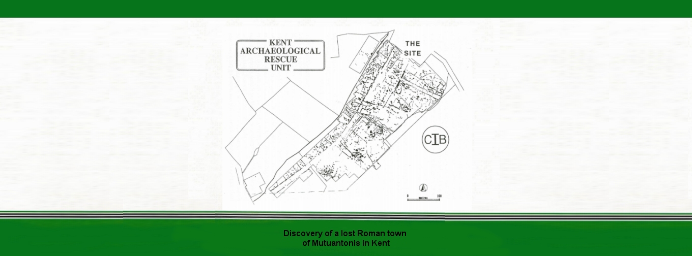
My identification is that this newly found Roman town south of Ashford is the actual candidate for the lost town! Emergency excavations there were carried out ahead of a major housing development in fields at Westhawk Farm, just two miles south of the centre of Ashford. This was directed by the experienced field archaeologist of the C.I.B. (The Kent Archaeological Rescue Unit.) Brian Philp. FSA, the founder of Rescue Unit with over 50 years in the front-line (Fig. 1). This work discovered the actual town.
The Unit's Geophysics Survey revealed many linear features showing the predominant part of the major Roman town with probable shops flanking a main Roman road which formed a regular pattern encompassing over more than 25 acres of land. Following evidence from the Geophysics Survey, the Kent Rescue Unit excavated 23 exploratory trenches in March, 1979. The excavations uncovered remains of pits, postholes, hollows, ditches and small enclosures and most important of all, traces of rectangular timber framed buildings and evidence of iron working smelting and smithing alongside the road. This Roman ribbon development, along a major route of communication, was created shortly after the Roman conquest. Other evidence of Roman occupation included burials dating to the late 1" and 2nd century and others finds include some tile other building materials and pottery (See Ref 3).
Significantly, this site is also the crossing point of two major Roman roads described by Margary (routes 130 and 131). This intersection was located 10 miles from Portus Lemanis (Lymnpe), 13 miles from Canterbury, 28 miles from Rochester and 15 miles or more from the Weald, which was then the centre of important iron-workings. Edna Mynott's article in the next KAR (Ref 4) suggested that it resembled a frontier town. The excavation yielded over 3,000 artefacts. It is also probable that it was an important market town supplying the needs of the many iron workers in the Weald and the surrounding areas. A strong Roman presence has also been recorded in the area along the routes of these Roman roads. The Roman infrastructure of this area was of great importance for the flow of trade supplies and communications, so it is not surprising that a town was located at this intersection. More extensive excavations (by others) were later carried out across part of the Westhawk site (Ref 5).
The town lies on the eastern side of the Wealden forest of "Anderida" and near the confluence of two important rivers the Great Stour and the East Stour and its smaller tributaries the Upper Great Stour. Whitewater Dyke and Ruckinge Dyke, tributaries of the larger rivers pass just a few yards to the south of the Roman town.
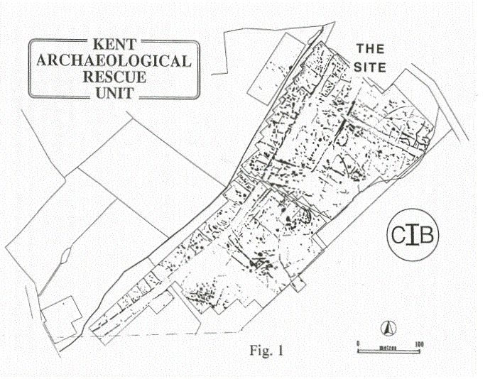
My attention was also focussed on the archaeological and historical development of adjacent area in Roman times. Other Roman settlements have been discovered in the environs south of Ashford that indicate there was increasing activity at the end of the Iron Age to the time of the Roman Conquest (Fig. 2). Some of these sites are along the course of the Roman road that runs through the Roman town located at Westhawk. To the west is Brisley Farm, Stanhope, where discoveries were made of a late Iron Age/early Roman settlement (200BC to 100AD). There the course of the Roman road passes just a few yards to the north and suggests that it had some direct link to the Roman town at Westhawk, which lies at a distance of about 700m. Other occupation sites along the Roman road are at Park Wood, located south-east of Westhawk. This produced pottery dating from 100 BC to 250AD. Another site, Park Farm, produced pre-Roman and Iron Age material dated 800BC-42AD. The Roman road then passed through Bilham Farm and Cheeseman's Green, where an early Roman site has produced an assemblage of imported Roman pottery, mostly from pits, post holes and gullies. Several features were thought to date from the late Iron Age-Early Romano-British period. A similar pattern was also recorded at Waterbrook Farm, Sevington. There a dispersed pattern of late Iron Age and Romano-British features included a complex sequence of ditches, cremation burials, hut circles, pits and post holes with continued occupation from 100BC to about 400AD. Finally, at Little Chart in Stambers Field, well west of Westhawk Farm there were associated finds that include Belgic pottery, Roman coins, tesserae, samian ware, part of a Roman Bath-house and three Anglo-Saxon skeletons with iron spearheads.
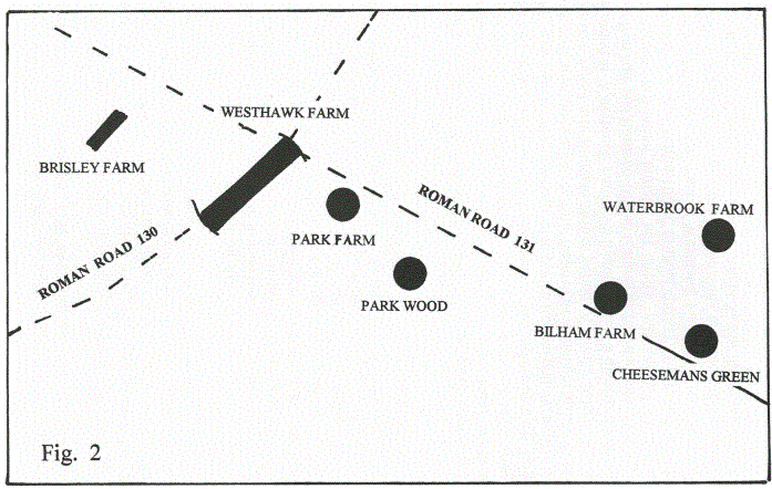
My assessment of the available evidence is that the site was the main administrative centre for essential trade and commerce for the wider Ashford area. This helps establish this as the most likely place for the lost town of Matuantonis as recorded in the Ravenna Cosmography. Not only this, but this identification makes much better sense of the local order of the Ravenna Cosmography (Fig. 3). It begins at Pevensey to the south-west from where a Roman road, partly already known as far as Bodiam, could link with Westhawk (via Margary 130). The order then passes to Lympne which, as stated above, certainly links directly with Westhawk (along Margary 131). The next listed sites are Dover and Canterbury, again directly linked with each other in a very sensible order. Richborough follows, again sensibly from Canterbury, but Rochester fails to continue any obvious trend. All this greatly helps with the identification of the lost town of Mutuantonis as Westhawk Farm, in the present parish of Kingsnorth! The decline of the iron industry in the Weald may have caused the demise of the town of Mutuantonis by the fourth century.
[Quote from Margary. 1. MUTU-, if from mottu- or muttu- cf, W. mwth, "swift". This would be a suitable first element in river-names or their derivatives. 2. Santon-, cf. SANTONI, SANTONES. Meaning: 'draining strongly' or 'flooding strongly'].
REFERENCES
1.1. A. Richmond and O.G.S. Crawford. The British section of the Ravenna Cosmography. Archaeologia XCIII (1949), p. 1-50.
- 1. D. Margary. Roman Roads in Britain,(1973).
- B. J. Philp, FSA. Roman Town discovered at Ashford, KAR No.133 (1998). p.57.
- Edna Mynott. The Roman Town Ashford, KAR No, 134 (1998) p.91
- Booth P, Bingham A-M and Lawrence S. 2008: The Roman Roadside Settlement at Westhawk Farm, Ashford, Kent excavations 1998-9. Oxford Monographs 2.
- Hicks M 1993 Park Farm, Ashford. Canterbury's Archaeology 1992 (1993), p.41-2. CAT.
- Rady J. 1992: Waterbrook Farm, Ashford. Canterbury's Archaeology 1991 (1992). p.32-34. 16th Annual Report, CAT.
- Justin Williams and Nick Lester. Timber Market Town, Kentish Express, 13.8.98